Conneaut Lake Aquatic Management Association
The Conneaut Lake Aquatic Management Association (CLAMA) was formed in direct response to public outcry about recreational usage problems caused by excessive aquatic vegetation in the lake. During the early 1990’s the Pennsylvania Department of Environmental Protection (DEP) was receiving concerns from the general public as well as local legislators about the excessive weed growth in the lake. At that point little was known about Conneaut Lake’s ecology or cause of the impairment. DEP contacted the Crawford County Conservation District for help addressing the issue. The Crawford County Conservation District was able to provide partial funding for an initial water quality of both the lake and its surrounding watershed. With the help of the DEP and local legislators the Conservation District was able to leverage additional funds from the State Conservation Commission to complete the study. Dr. Milt Ostrofsky was contracted by the Conservation District to conduct an assessment of the lake. Later an EPA phase I assessment was also conducted on Conneaut Lake to identify the source of the impairment as well as make recommendations to correct it. Both studies pointed to excessive phosphorous loading in the lake as the source of the excessive growth of an invasive plant species called Eurasian Water milfoil.
Phosphorous, a nutrient commonly found in both agricultural and backyard fertilizers, was feeding the plant growth as well as causing summer algae blooms on the lake. The EPA Phase I assessment gave several recommendations, including working with local residents to reduce the amount of phosphorus entering the lake. The assessment also recommended working to reduce the plant growth within the lake using various techniques such as harvesting and application of aquatic herbicide. Another recommendation from the assessment was the formation of an association of local stakeholders to make decisions on management of the lake. With the help of local State Representative Jim Merry that recommendation became a reality. The Conneaut Lake Aquatic Management Association was born with representation from homeowners, area businesses, the Conservation District, sportsmen, agriculture, academia, as well as others. Ever since then the resulting organization has worked tirelessly to manage Conneaut Lake in a way to meet its many ecological, recreational, and economic needs. Over the years CLAMA has coordinated an aquatic plant harvesting program, herbicide application, and water quality monitoring for the lake. CLAMA has also leveraged state and federal grants to reduce nutrient runoff from local farms and address residential storm water issues. Each year CLAMA coordinates fundraising events aimed to fund the services needed to maintain a clean, healthy lake for everyone to use.
Click here to support CLAMA!
Glacial Lake Morphology
The retreat of the glacier was very slow, and for several centuries after the formation of the lake the landscape resembled modern-day arctic tundra.
During this early time period large amounts of soil washed off of the landscape providing an initial flush of nutrients into the lake. This would have taken place until trees and plants became established. With the climate slowly warming up the area around Conneaut Lake would have changed from tundra to boreal forest, and then ultimately today’s hardwood forest. The vegetation would have held soil and nutrients from entering the lake. In this state the lake would have been classified as oligotrophic, or nutrient poor. Without excessive nutrients the water of the lake would have been very clear, and plant growth would not have been excessive.
It has been assumed that populations of Native Americans were small, and that their effect on the natural environment was minimal. However the beginning of the19th century saw increasing settlement around the lake and its watershed. This arrival of European settlers led to deforestation, agriculture, and more recently, urbanization. All of these activities increase nutrients entering the lake. Nutrients in the form of nitrogen and especially phosphorous act as fertilizer for the lake. The increase in these nutrients running into the lake has resulted in decreased water clarity and increases in algae and nuisance rooted aquatic plants.
The science of lake management is focused on strategies to lessen the negative effects of increased nutrient loading to lakes, and if possible, reduce that nutrient loading. Methods of reducing the amount of nutrient loading range from the very simple – maintaining deep rooted trees and shrubs to intercept runoff and stabilize soil – to very complex – whole lake treatment with aluminum salts to prevent nutrient within the lake sediment from stirring up each year.
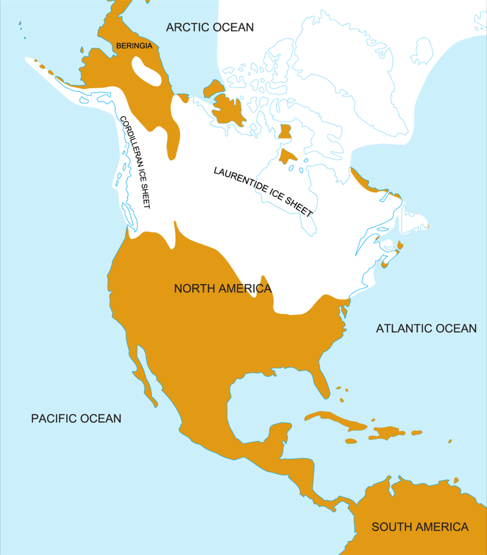
The Earth’s history has been marked by a series of ice ages. The most recent ice advance period was the Wisconsin glaciation that extended from about 85,000 to 11,000 years ago. The maximum advance of the glacial ice sheets occurred about 20,000 year ago and covered about half of the North American continent.
Source: http://www.zonu.com/fullsize-en/2009-11-09-10972/Wisconsin-glaciation.html
During the time, however, much of Pennsylvania was spared with only the northeastern-most and northwestern-most areas covered with ice.
Source: Sevon, W. D. and G. M. Fleeger. 1999. Pennsylvania and the Ice Age. PA Geol. Survey. 4th Series, Educational Series 6. Harrisburg, PA. 30 p.
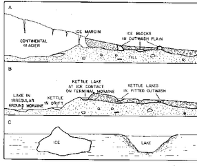
As the glaciers melted, large blocks of ice were broken off and partially buried. These large ice blocks created depressions in the landscape, and when the ice melted, became lakes called kettle lakes because of their shape.
Source: Hutchinson, G. E. 1957. A Treatise on Limnology. Vol. 1: Geography, Physics, and Chemistry. John Wiley & Sons, NY. 1015 p.
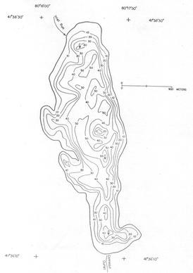
Conneaut Lake is a good example of a glacial kettle lake. However, rather than one kettle like basin Conneaut Lake contains three distinct basins. It is thought that three separate blocks of ice broken off from the glacier created these basins. To the left is a map of Conneaut Lake called a bathymetric map. This map shows the three separate depressions.
Source: Environmental Protection Agency. 1975. Report on Conneaut Lake, Crawford County, Pennsylvania. Working Paper No 417. USEPA. Washington DC.
Lake Ecology
- Located in Crawford County
- Largest natural lake in Pennsylvania
- Eutrophic: rich in nutrients
- 7 miles west of the city of Meadville
- 930 acres
- 1 mile wide, 3 miles long
- Maximum depth – 60 ft
- Plant Species found in Conneaut Lake
- Conneaut Lake Facts
Fishing
- Pennsylvania Fish and Boat Commission
- Best Pumpkinseed and Bluegill Lakes
- Walleye and Muskellunge Fingerlings are stocked in the lake annually
- Warm water sport fishes are managed by the Statewide Regulations for Commonwealth Inland Waters
- Shoreline is limited to fishing due to private property regulations
- Boat is more preferred for lake fishing
Public Recreation
- Unlimited horsepower regulation for boating activities
- There are 3 boat launches:
- Private – Nye’s Marina
- Public – Pennsylvania Fish and Boat Commission
- Public – Fireman’s Beach
- Dock slips can be rented during the summer